| Age | : 53 years |
| Population | : 801, 707 (In Year 2000) |
| Temperature | : Min 10°C – Max 43.3°C |
| Location | : Latitude 21° 58′ N, Longitude 96° 04′ E |
History of Mandalay
King Mindon, making it the capital of an independent kingdom for less than 30 years, had founded the town only 29 years earlier in 1857. Contrary to other Burmese towns, especially Yangon, Mandalay has not grown from a smaller settlement to town proportions. In 1857 Mandalay was set up in an empty area, because, according to an ancient prophecy, in that exact place a town would come into existence on occasion of the 2,400th jubilee of Buddhism.
The city was named after the Mandalay Hill, which is situated at the northeast corner of the present city. The hill has for long been a holy mount and it is believed that Lord Buddha prophesied that a great city, metropolis of Buddhism, would be founded at its foot. It was King Mindon who fulfilled the prophecy.
King Mindon decided to fulfill the prophecy and during his reign in the Kingdom of Amarapura he issued a royal order on 13 January, A.D 1857 to establish a new kingdom. The Ceremony of Ascending the Throne was celebrated in July, 1858. The royal city and the kingdom were demarcated. The whole royal city was called Lay Kyun Aung Mye (“Victorious Land over the Four Islands”) and the royal palace, the Mya Nan San Kyaw (“The Royal Emerald Palace”). The kingdom was called the Kingdom of Yadanabon, along with other name Ratanapura, means ” The Bejeweled Site “. Later it was called Mandalay after the Mandalay Hill, 2.5km far to the north east of the royal palace, and today the name still exists. The name ” Mandalay ” is a derivative of the Pali word ” Mandala “, which means” a plains land “and also that of the Pali word ” Mandare “, which means “an auspicious land “. At that time a transfer of the capital not only meant leaving an old town and erecting a new town in a different place. As all secular buildings of that time, including the royal palaces, were built from wood, a transfer of the capital meant the complete dismantling of the houses of the old settlement, which then were loaded on carts and the backs of elephants to be reconstructed at the place chosen for the new town. This way of moving entire capitals is a tradition in Myanmar. The transfer of the capital from Amarapura to Mandalay had not been the first of its kind. The most important Burmese town of the northern Ayeyarwaddy valley had for a long time been the town of Ava, founded in 1364, about 20 kilometers southwest of Mandalay. In 1636 at that time, powerful royal family from Taungu about 280 kilometers north of Yangon and 320 kilometers south of Mandalay moved to Ava and made it the capital of a Burmese realm roughly equaling the extent of the present Burmese state.
But in 1782 the town was packed up and moved about 8 kilometers to the Northeast, to the aforementioned Amarapura. In 1823 the entire capital was dismantled again and rebuilt 8 kilometers Southwest in Ava. But in 1838 Ava was damaged by an earthquake, and was therefore in 1841 packed up again and once more transferred to Amarapura. But this was not of duration either, as only 16 years later the entire town was moved again this time 12 kilometers to the Northeast to the present Mandalay. Who, in the face of all this moving of the Burmese capital, might assume that it was more or less only a temporary camp of tents, is very wrong. At least the royal palaces, despite their being made from wood, were immensely large. Many, enormous teakwood tree trunks served as pillars to support the royal palaces, often several stories high.
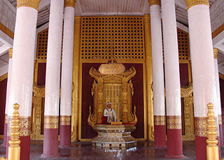
The rhyming couplet easy to memorize the year of building the royal city is ” Okkyit-Kyaw Aye / Mandalay ” or ” Aung Kyaw Chan Aye / Mandalay ” ( i.e, M.E 1221 ). The city’s layout of the construction is the same at that of the earlier Kingdom of Amarapura, and from the bird’s eye-view, it has the structure of geographical squares and rectangular shapes, with streets and roads crossing one another at right angles. There are four parts dividing the city, namely, Ashe-pyin ( East Part ), Anok-pyin (west Part), Taung-pyin (southern part) and Myauk-pyin (Northern Part), with 54 plots. With the Ground-breaking ceremony, King Mindon laid the foundation of Mandalay on the 6th waning day of Kason, M.E 1221, (A.D 1857). The King simultaneously laid the foundations of seven edifices: the royal city with the battlemented walls, the moat surrounding it, the Maha Lawka Marazein Stupa, the higher ordination hall named the Pahtan-haw Shwe Thein, the Atumashi ( the Incomparable ) monastery, the Thudhama Zayats or public houses for preaching the Doctrine, and the library for the Buddhist scriptures.
When King Mindon passed away, his son King Thibaw ascended the throne, and in M.E 1247, Myanmar fell under the British colony. It was the old capital ruled by two successive kings the one where the last of Myanmar’s monarchs reigned.
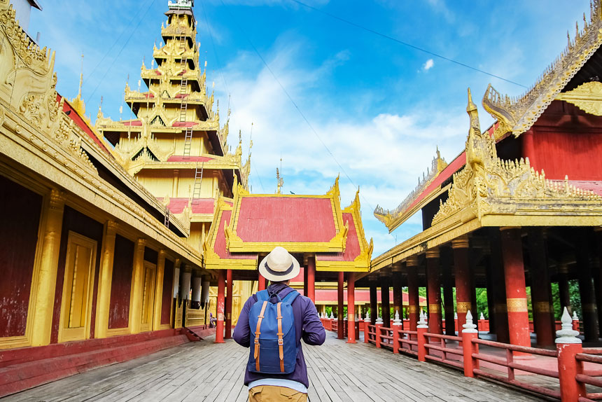
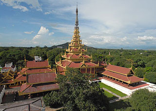
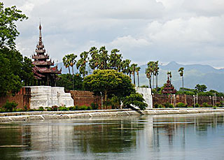
After the British had conquered Mandalay in 1886 they turned the royal palaces of Mandalay into their military headquarters and christened the complex Fort Dufferin.
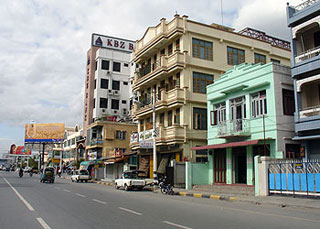
During World War II the Japanese installed a military camp in the same place, which then was bombed by the allies, until nothing was left of the ancient palace buildings. Mandalay today is a striking phenomenon composed of modern and classic images with the ancient cultural beauty of the royal palace and the moat surrounding it, and the natural impressionistic beauty of the Mandalay Hill, harmoniously added with new architectural photography of modern houses and brick buildings. The former palace ground is known by the name of Fort Mandalay. Of the ancient palaces a few concrete replica have been built and further reconstructions are being conducted.
Comment (0)