Exploration to the Mountains of Myanmar
Mount Khakaborazi
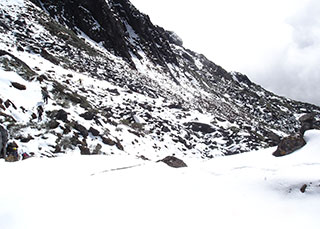
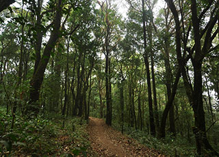
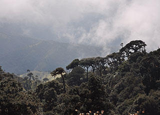
Mount Khakaborazi is Southeast Asia’s highest mountain. located in the northern Myanmar state of Kachin. The elevation of this mountain is 5.881 metres (19.294 feet). It has extended from the range of Himalaya. The coordinates are 28°19’59″N. 97°28’00″E. The peak is enclosed within Khakaborazi National Park. It is entirely mountainous and is characterized by broad-leaved evergreen rain forest. a sub-tropical temperate zone from 8.000 ft to 9.000 ft. (2.438 m to 2.743 m). then broad-leaved. semi-deciduous forest and finally needle-leaved evergreen. snow forest. Above 11.000 ft. (3.353 m) the highest forest zone is alpine. different not only in kind from the forest. but different in history and origin. Still higher up. around 15.000 ft. (4.572 m). cold. barren. windswept terrain and permanent snow and glaciers dominate. At around 17.500 ft. (5.334 m). there is a large ice cap with several outlet glaciers.
Climbing Tips
The mountain was first ascended on September 15. 1996 by Takashi Ozaki (Japan) and Nyama Gyaltsen (Myanmar). The easiest route is snow or ice climb.
Mount Hponkan Razi
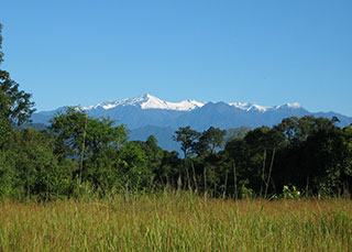
Hponkan Razi Mountain is situated in Putao Township. Kachin State. in the uppermost part of Myanmar. Hiking. Walking and recreation in the natural forest environment is the main attraction of this mountain. There are opportunities for studying the tradition. culture and life style of indigenous hill tribes. Hponkan Razi is usually snow-capped half the year. Rare mammals and bird species dwell in this region. which can survive in high altitude. Observing 30 mammal species including Red Panda. Takin. Red goral which can be found in East-Himalayan. There are over 200 bird species including Monayrit and hill pine forest. evergreen forest. medicinal plants and wild rare orchids. To reach this mountain. one has to travel to Putao first and to proceed with the arranged journey from the tour operator.
Nat Ma Taung
Nat Ma Taung (or) Mount Victoria. national park is located in Kanpet-let. Mindut and Matupi townships of southern Chin State. It covers an area of 279 square miles. and is established in 1994. The Mountain is about 320 miles. from Yangon to Bagan-Nyaung-Oo. by flight. Bagan-Nyaung-Oo to Chauk. 18 miles by car. Chauk via Seikpyu to Hsaw. 68 miles by car and Hsaw to Kan-pet-let. 12 miles by car or Hsaw to Mindut. 42 miles by car.
Nat Ma mountain national park preserve rare species of Myanmar Orchids. To educate local people to shift from practising shifting cultivation to cultivating perennial plants and trees. To promote and upgrade the park as an ecotourism attraction. To attract tourists with water rafting and rapid-shooting during the rainy season while the river flow is rapid.
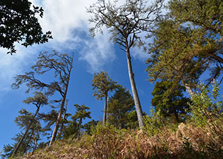
Forests include hill evergreen forests. moist upper mixed deciduous forests. pine forests (above 9000 feet). and hill savannah.
Mammals such as tiger. bear. wild boar. leopard. goar. serow. gibbon. etc. and 159 bird species. reptiles and butterfly are present. Education and prohibiting of shifting cultivation in the protected areas. Inventory of forest flora. Study and research on bird species and their natural habitats.
Establishment of modern Forest Village with the assistance of rule people to initiate a permanent Taungya planning system with perennial plants. Conducting a field survey and inventory to promote and upgrade the park for ecotourism industry.
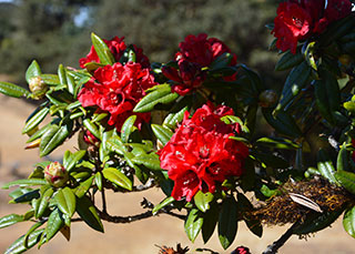
Participation in organized Orchid Tours where the most attractive Myanmar Orchids exist. Observing the traditional and cultural eritage of Chin pople and their living systems. Observing the natural forest and trees. especially Rhodoendron arboreum. Accommodation for 5 persons at the guest house.
Comment (0)